How fiber mapping software cuts costs – Part 2: Unlocking savings with 3-GIS
In Part 1 of this series, we explored how fiber mapping software can optimize both CapEx and OpEx by improving accuracy, streamlining operations, and...



Faster installs depend on more than speed. Watch how connected orders, field work, and network records keeps Waterloo Fiber moving from request to activation.

Inspection findings should not sit in reports. Watch how Modesto Irrigation District moves field findings into repair assignments teams can act on.
3 min read

When the National Telecommunications and Information Administration (NTIA) released its BEAD Restructuring Policy Notice in June 2025, most attention focused on changes to funding priorities and fiber-first policies. But buried deeper in the guidance is something with real operational weight: a new federal requirement for environmental permitting coordination.
As of now, every BEAD awardee must use the NTIA’s Environmental Screening and Permitting Tracking Tool (ESAPTT) for any project requiring review under the National Environmental Policy Act (NEPA).1 According to NTIA, this move will “significantly reduce the time and effort required for broadband permitting.”2 That could mean cutting 3–6 months off approval timelines—if awardees have their network data ready.
This didn’t happen overnight. The ESAPTT tool is part of a multi-year federal effort to modernize environmental reviews and speed up broadband deployment.
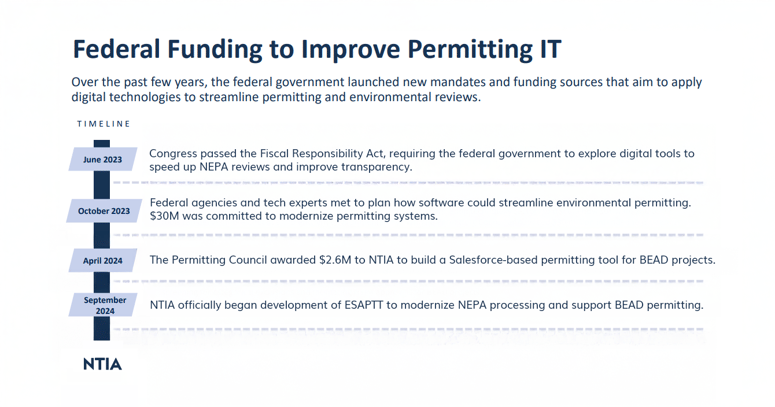
Image source: NTIA
ESAPTT moves fast—but only if your network data is spatially accurate and submission-ready.
ESAPTT is a permitting workflow tool embedded in the NTIA Grants Portal. It’s designed to:
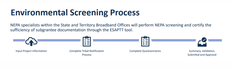
Image source: NTIA
NTIA says the goal is to "lower costs, speed up implementation, and ensure all technology solutions are considered" during the subgrantee selection and approval process.2 But for the tool to actually accelerate deployment, you need clear, accurate location data at every stage—from design to submittal.
Every mile of fiber, every pole, and every vault must be located, documented, and justified. Many teams still manage this part manually—redlining PDFs, emailing maps, or juggling files between contractors and state portals. That’s where avoidable delays begin.
GIS-based fiber management software fixes that, allowing agencies to:
It’s not just better data. It’s the ability to prove what’s happening on the ground, before a regulator ever asks.
Under the new rules, states must conduct a Benefit of the Bargain Round to reopen subgrantee selection. This means previously awarded projects will be re-evaluated, and new permitting reviews will be part of the process.1
The pressure to act fast is real. With new guidelines in place and states reopening subgrantee selection, the timeline to secure approvals and start construction is tighter than ever. But that momentum only turns into real progress if you’re ready with complete environmental documentation, starting with location-based design.
The full process looks something like this—GIS helps you enter at the top of the flowchart with clean data, rather than getting stuck halfway through:
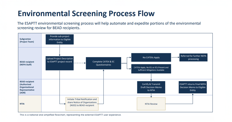
Image source: NTIA
While ESAPTT is federal software, it doesn’t create or manage your network data. That’s still up to you.
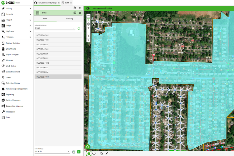
GIS-based platforms like 3-GIS | Web and supporting field tools such as 3-GIS | Mobile provide:
Once your design data is uploaded, ESAPTT allows eligible entities to track every step of the permit lifecycle in real time:
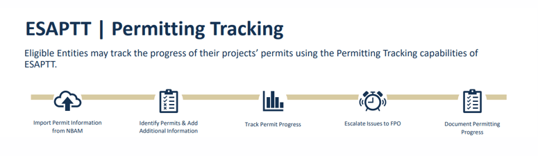
Image source: NTIA
In other words, ESAPTT can’t replace your GIS—but your GIS can make ESAPTT work better.
NTIA’s new permitting process was designed to speed up broadband deployment. But it also sets a higher bar for accuracy, transparency, and coordination. The Fiber Broadband Association summed it up well:
“Fiber is the most reliable, scalable, and cost-efficient technology on the market... and is uniquely positioned to serve as the backbone to our nation’s broadband infrastructure.”2
And as more states pivot from planning to approvals, the providers who come to the table with GIS-ready data will be the ones who move first.
Because with $42 billion in play, speed isn’t just an advantage. It’s the requirement.
Want to see how GIS can support your permitting process from the start? Talk with a 3-GIS team member today.
Citations
1 NTIA, BEAD Restructuring Policy Notice, Sections 3.3 and 6, June 2025
https://www.ntia.gov/sites/default/files/2025-06/bead-restructuring-policy-notice.pdf
2 Leslie Stimson, Inside Towers, “Reactions to BEAD Changes Are Strong,” June 10, 2025 https://insidetowers.com/reactions-to-bead-changes-are-strong
3 NTIA, Environmental Screening and Permitting Tracking Tool (ESAPTT) Overview, June 2025 https://broadbandusa.ntia.gov/sites/default/files/2025-06/ESAPTT_Overview.pdf
In Part 1 of this series, we explored how fiber mapping software can optimize both CapEx and OpEx by improving accuracy, streamlining operations, and...
Back in 2021, Congress allocated $42.45 billion to the NTIA to create the Broadband Equity, Access, and Deployment Program—or BEAD. This was done to...
Across Canada, fiber projects are reshaping how people connect, learn, and work. But behind every new strand of cable lies a complex story of...